Jump to content

phdhorn

Legacy Members
  • Posts

    6434
  • Joined

Everything posted by phdhorn

  1. 29-8 win against the Nats today. Twenty-nine. We're going to win the World Series this year. Book it. Well, okay we'll probably barely get to .500. Anyway, that was different.
  2. If that's not bad enough, that map is just the males.
  3. I don't know about all that, but the big question is, at the dinner, are they going to serve tempura? Or kitakata or whatever the hell they serve?
  4. Tonight overnight: - a little rain toward sunrise - little/no severe - clear by early morning - carry on
  5. Yes, they've promised never to schedule Kansas or Maryland.
  6. Google News >>>>>>>> Yahoo or other sites because you can customize it. Once I took off the bullshit fake news hard left and hard right sites it's tailored pretty well for me.
  7. Just don't ever get rid of their cool striped socks. That's my mantra for this year.
  8. Das Andere Boot! Sieg Heil!
  9. Good for him! Poor kid deserves it. Although shit if Id've known that I would've driven my '96 Explorer into an F1. Of course, not sure what they'd give an old white guy but I can fake like I don't speak English if that helps.
  10. An oldie but a goodie... totes reminds me of this (points/Ameros if you know this) https://ytcutter.net/watch/htwb9ONv2/
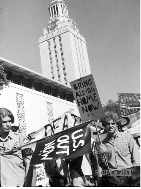
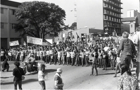
  11. Well, my police work started with the thread title... West Mall. Not disagreeing that the south side can accommodate that but I was pretty familiar with a lot of older faculty and students who all had the same story and gave it to me without much difference. Really same goes for the east side. And both still can have crowds; just not the huge ones that could form on the drag. Not sure what it is about West Mall except it was always traditionally the spot for gatherings, etc. Not sure if it was a designated "free speech" area or what. Here are 2 pix I found of back in the day (I think 1971): Notice in the left photo that it's definitely West Mall, and you can see where there seems to be an unbroken crowd behind the guys in front - before the put up the "tree beds". The right photo is clearly of the drag, I think just down below 21st. One reason the West Mall in particular was "the" demo place was because crowds could form and march to/from it on the Drag (which happened a lot). Again, South and East sides of Main Building had the space, but the West side always had the demonstrations, that much is clear. As is the title of this thread. That's what I heard and I'm stickin' to it.
  12. Wouldn't be surprised if it was well up there, even a 4 at points. The CentTex tornadoes were as follows, at this point (could change): 000 NOUS44 KEWX 232152 PNSEWX TXZ194-241000- Public Information Statement National Weather Service Austin/San Antonio TX 452 PM CDT Wed Mar 23 2022 ...Preliminary Tornado Information from Surveys... The following information is preliminary on the tornadoes that have been confirmed from Monday March 21 in South Central Texas. More rating and track details are being finalized this week from additional photos, flyovers, and even drone footage from our emergency management partners...and detailed Public Information Statements will be issued. Ground surveys were completed today in Jarrell and Giddings. Of note is a correction on the Kingsbury Max wind from an earlier PNS issuance. Tornado Name Prelim Max Rating / Max Wind Speed _______________________________________________________________ Elgin Tornado EF-2 / 130 MPH Kingsbury Tornado EF-2 / 115 MPH (correction) Round Rock - Granger EF-2 / 135 MPH Jarrell EF-1 / 100 MPH Giddings EF-1 / 95 MPH As we study and look at additional photos, EF ratings could change. Round Rock might easily get boosted to EF-3, which begins at... wait for it... 136 mph.
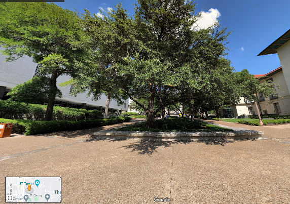
  13. Even before I got to the blah blah blah of this thread, I found the question in the OP somewhat irrelevant. This is before most of our time, but some time in the 70's, the West Mall, which was a big blank plaza, was "reconstructed" with those giant flower boxes or tree bed things, or whatever. By doing so, they knocked out 2/3 of the West Mall space. You think they did that for "decoration?" No, they did it so students had a more difficult time congregating there. Sure they still had their little rallies and stuff but it was nothing compared to the Vietnam era ones, when crowds spilled out onto the Drag, frequently blocking it. So, today you see this instead of an empty large plaza: While it existed before/when I got there, older timers told me repeatedly of how they did it after the demonstrations in the 60's - it was common knowledge. So the question is already answered. The West Mall stopped welcoming free speech, and built stuff to inhibit it, long before any of us got there.
  14. Next storm event scheduled for late Tuesday/into Wednesday. Severe? Possibly. Anything approaching within a galaxy of the last event? No. That won't happen for 10 years again at least. Book it. No, really, book it.
  15. The uniforms look snappy & the stadium looks very nice. I absolutely guarantee two wins for sure this year!!!
  16. Not much, as I don't want to predict/zpeak for them. However, if it were me, 5 things to consider. 1) The highest risk area is in Northern Louisiana and Central Mississippi, but New Orleans in the enhanced, so yeah there's a risk. But I think any air delays would be short-lived. 2) As long as a plane isn't trying to take off in the middle of a thunderstorm, they're pretty good about maneuvering around it. That wouldn't bother me flying. Unless there's damage to the airport, most thunderstorm delays are 30 - 60 minutes at worse unless a connection is late. But they probably get home the same night. 3) Zero hour for NOLA airport is roughly 4 - 7 p.m. for the storms to hit. If you know what time they're scheduled to take off, consider that. 4) it wouldn't be worth it to me to try to drive because I don't think the flights will be all that messed up at least to delay overnight or something. But if I were to drive, I would make DAMN SURE that I was nowhere near the long I-10 trestle bridge across the Atchafalaya Basin when I pass under the storms. There's nowhere to go on that and it's the worst place to be. If I knew I'd clear it into SW Louisiana before or afterwards I might do it. No way in this life or the next I'd drive under a severe thunderstorm on that part of i-10 if I could possibly help it. 5) finally I'd have phone apps running and weather channels playing on TV exits planned out just so they can get off the road and away from a storm that might spawn a tornado or hail. All in all, I'd stay at the airport and wait it out. That's just me.
  17. I wouldn't worry, it won't be bad or long-lasting.
  18. Good thing the poo supplies store was intact though!
  19. Just about to come in with this. Should not be severe, still could be a bit poppy though. But this last line should be it for this event. Officially watches etc. not expire until 10, but most of the energy is out of the atmosphere where it was bad earlier.
  20. Should be a lot of coverage on 10 news. Not surprising, that probably was a high F2 at least, likely F3, to mess up roofs.
  21. Post-mortem: I hope people in ATX and immediate realize how freaking lucky we've been. The severe prediction map was spot on! The storms started blowing up just west of Austin, giving most of us light rotation and brief, spotty pinpoints of smaller but damaging hail. But all in all we got off pretty damn well. Once this line moved just into and through Austin, it really blew up. And that's exactly where the "moderate risk" area was mapped. The Round Rock tornado was the first instant of these storms super-charging into monsters. And now they're all blowing up east of us. If this event was just 10 miles west, these storms would have wreaked a lot more havoc over heavily-populated Travis/Austin. The worst it did was to glance Round Rock before moving into much smaller populations. We were very fortunate, period. That said, I can't remember a heavier outbreak for our area, some 17-18 tornado warnings forecast within a 75 mile radius of Austin. And those weren't even the worst. T and P for our eastern and NE neighbors. Going to be a long evening. I must say, the forecasters fucking nailed this forecast as well as I've ever seen. I mean amazingly. Good work.
  22. Another likely tornado coming in near COTA heading for Webberville. Confirmed tornado in Caldwell Co. A third possible east of ABIA in E. Travis.
  23. Sorry, just jumped in, new area of concern for SW part of Metro, heading into West Central Austin. Now it's raining hard in Bee Cave but no severe - rigt now. Large tornado on ground in Pflugerville. Shit breaking out all over us. Now you know what "Moderate Risk" means.
  24. Ooh, before I go, tornado warning for - Jarrell. Ugh. That tornado is expected to be very bad. Keep in mind these storms are gonna get worse as they move east into eastern Texas this evening. Multiple tornadoes expected.
×
×
  • Create New...