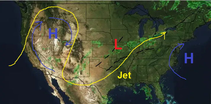
Alright, lemme e-lab-bore-ate. Nice way to usher in July (those who were saying "the cool weather's gone" were a bit preemy, huh? - never say never, but yeah, I know that probably after this stretch we could be in the smelter once and for all, but I have reason to doubt a bit.... another post... remind me to say why).
We got an interesting 2-ply scenario here. First, a typical summer savior - weather coming in from the Gulf. A low is moving E to W towards us. This is due to the summer jet lifting more N and allowing the Easterlies to expand and blow stuff our way (which is also why hurricanes come towards the U.S.). So it's always good when we get weather from the Gulf in the summer. But the second situation over the country is a bit unusual... a big blocking high in the East is preventing weather from moving W→E, so the weather is being squeezed SE, much as a winter or spring pattern. And we got that bigass hot high out west baking the NW, which is preventing storms from tracking to the N in the first place, so they are swinging below it into the southwest U.S. So that's forcing a frontal boundary down into Texas, which is kinda rare (although we just had one last week). As a result, we have a one-two punch. The front from the NW will hang out for a few days, and stuff under it, esp. just to its south, will get wet (where that is is a dice roll). The low is going to move into us, and now it looks like it'll collide more with the front to produce more lift, and more weather - this is why models have trended up the past 2-3 days. Of course, this is Austin, and it's summer, so Ron Paul It's Not Happening can dominate (i.e. predicted shit fizzles out). Never say never regarding that in Austin in the summer.
But, I think there will be enough mixing up of crap with these two things that it would be highly unlikely that at least something wouldn't fall over you, even if for a brief spell, over the next 4 days. I think a good swath will get a good amount of rain, not flooding or anything, but enough to re-wet the ground and keep temps down yet another week or two (in the summer, every day under 100° is one less day it might go over it). But where this swath is? <crickets>. Hopefully over us.
Of course the best thing about this, with or without rain, is temperatures. We're expeting a full 5-6 days of under norms, and at least 1-2 of those under 90° (and despite the weeping/gnashing of teeth above over 2/3 of June, it only officially got over 100° 2 days - that's it. Not as bad as thought). So anyway, this should be a very nice week - yeah a bit soupy but lots of clouds and hopefully some good soaking rain. I. Will. Take. That. Any. Day. In. July. Bitches. So therefore: Today - noticeably cloudier through the day, temps a little lower than the last few, although I could see them getting easily into mid-90's, looking more like 93° or so max in the hottest parts, cooler in most. Chance of spotty showers pretty good starting mid-afternoon. Not everywhere, but enough that a lot of us will see them. Mon-Wed - this is the peak of it all, with Tues-Wed. especially, as the low moves into Texas and bumps into the front. Again, where that front stalls or slows will be the mostest rain. Days will be clearly cooler, lots of clouds again and hopefully a good bit of rain for most of us. I hurt writing that, because it is summer in Austin, yeah right, but I think this is gonna happen to some degree. Thu-Fri - rinse and repeat, but gradually increasing sunshine and temps, decreasing rain chances. Highs back near 97° ish, rain returns to spotty and scattered, but definitely still in the picture.
Outdoor plans should be decent today (but watch after about 3-4, but nothing severe or long-lasting). Not so great Mon-Wed, and good enough to risk Thur-Fri. 4th fireworks etc... too soon to comment on that in detail, but probably decent as most of the weather will have ended by then.


